"Could I have this dance for the rest of my life?" - Anne Murray

Friday, May 30, 2014

Smith Rock State Park: Our Astounding Accomplishment

Memorial Day weekend at the most popular hiking/climbing location in Central Oregon. What were we thinking? We almost turned back when we saw the cars parked more than a mile away from the entrance to Smith Rock State Park. But we thought we'd just get a little closer and see what there was to see, and we found a parking spot right close to the entrance, so of course we had to go on in and do the park. First tough choice made.

After visiting the facilities and paying our entrance fee. the next big choice was which hike to take. There are 12 different hikes identified on the park map, from short and easy to the infamous "Misery Ridge Trail" that goes to the summit of the most imposing rock in the park. Mmm…

This….


Or this...
(just the easy beginning of Misery Ridge Trail)


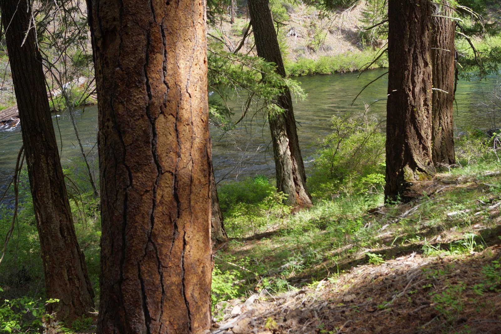
I looked up at the top of the giant rock face in front of us (3,660 feet) and thought I didn't need to be up there.  Rick concurred without pressure so we headed down the River Trail through the truly gorgeous valley created by the Crooked River. 


Ahh...


In addition to the occasional fly fisherman there were many rock climbers all along the faces of the rocks. You can see all the handholds on this popular rock face by the white chalk left behind. There were lots of climbing classes going on at these locations along the River Trail.


About 2 miles down the mostly level trail, Rick was ready to turn around, but I said, "Let's just go to the place where the trail turns around the back side of the rock and see if we can see the famous Monkey Face rock." So we did that. Rick's a trooper.

There it is! Monkey Face!


Then Rick, the trooper, said, "Let's just get a little closer to get some good pictures." See the monkey face? There are actually two climbers sitting on the ledge that you could imagine would be the monkey's collar if he had a shirt on. You could probably zoom in and see them.


By this time we were approaching Mesa Verde Trail, and the trooper says, "Shall we just make a loop of it?" Sure, sounds like an easy decision right? No, what this means is deciding to go up and over the top of Misery Ridge and down the side we decided earlier not to tackle. But we've been seeing all these people of every conceivable shape, size, age and ability, including folks carrying their babies on their backs, with every conceivable kind of footwear, including flip flops, coming down off the rock with big grins on their faces. It was very tempting to give it a try.

Here's the map, and the only information we really had.  We were on the back side, 2 miles into the hike, still along the river, facing another 1.5 miles up and over on the red zig-zagging trail. Everyone else seems to be going the other way.

What would you do?


Well, I guess you figured out that we went for it. Here's the view that rewarded us as we ascended (huffing and puffing) the gentle Mesa Verde Trail diagonally up the side of the mountain. (I don't know what to call this thing. It's bigger and more complex than a "rock" and not exactly what you think of as a mountain.)


At the top of Mesa Verde Trail there is an alcove where people wedge little rocks to mark their completion of Misery Ridge Trail. It serves as inspiration to all the fools who come up the wrong way.


Another big moment. Stepping on to Misery Ridge Trail. This is the first time we've ever tackled a "most difficult" trail. What a bunch of mixed messages we were getting. The ranger at the bottom seemed to be telling us it was no big deal, just take our time…kids in flip flops…infants in back packs…and this sign.  Oh boy.


We plunge ahead. But what we were doing was nothing compared to the climbers all around us, including those tackling Monkey Face. (Notice the snow covered mountains in the distance?)


Finally we get to what seems to be the top and we take a break to look out over the incredible landscape to the west. That's still Monkey Face on the left, but now we're above it. 


This next quarter mile follows the top ridge and is nowhere near as scary as it looked from down below. There are magnificent views at every turn.


Here's a choice we didn't make. There were plenty of daring folks up at this height, including tightrope walkers and acrobats doing their thing. Unbelievable. 


We stuck to the main trail and felt incredibly grateful for the whole experience. I got a little ecstatic high as we bridged over the summit and started our way down the other side. Now I know why all those people we passed were smiling.

Here's another choice we didn't make. That's the Burma Road Trail on the mountains across the way. Another day maybe?


So, it was a long way down, with switch backs and slippery rocky/sandy trail surfaces in some places.


Stairs, thank goodness, in other places.


As we got near the bottom, I hate to say it, but my body was complaining a bit, and I had to take it kind of slow. Rick didn't seem to be having any troubles at all. I told you he was a trooper.


The many climbers along the Red Wall provided some distractions and reasons to stop and take a break to watch.


Finally! We made it!


The shadows were long as we eased ourselves across the footbridge where we made our first decision not to do Misery Ridge. But I'm so glad we changed our minds and went for it. We were tired but really proud of ourselves, and so rewarded by the views of this amazing state.

By the way, we're in Bend, Oregon for the month. I'll have to say more about Bend at some point. We're really liking it.

Wednesday, May 28, 2014

Hiking Along the Metolius River: Camp Sherman, OR

Another one of my solo hiking days. For my birthday, Rick bought me a PLB - that's a Personal Locator Beacon - so that when I go off hiking by myself I'll have an emergency calling device in case anything life-threatening happens to me. I just have to press the button on the small hand-held gizmo and it sends an alert and a GPS location to a "Mission Control Center," that then organizes a rescue. It's a good idea. We both feel safer already.


The hike of the day was along the Metolius River, just north of the town of Sisters.  I got information about the hike from the Sisters Chamber of Commerce and Visitor's Information Office. Basically, you take 126 northwest out of Sisters until you get to 14, then turn right or north onto 14 and follow signs to the little town of Camp Sherman. Camp Sherman consists of a small resort, RV park and general store in the midst of a remote summer home/camp community clustered around the woodsy Metolius River. (There are internet resources that can give you more details about the hike and the surrounding area.) 


From the bridge at Camp Sherman you can hike north or south along the river, or drive further north on 14 to the Wizard Falls Fish Hatchery and pick up the river side trails there.  I did both. The lower end is  residential on the west side and park land on the east side where the trail is, and the river is gentle. It grows as it flows north, deepening and cutting through gorges as it's fed by other springs along the way. By the time it gets to Wizard Falls it's really ripping.


I guess this is Spring high water for the Metolius. Looking down at it from the bridge at the fish hatchery, and from the banks high above the gorge, you can see the bright turquoise water in the deep central channel in contrast to the dark shallow water that runs over rocks and vegetation near the banks. Now I'm not sure about why the deeper water would be lighter, but I think it has to do with how much air is bubbling around in it. 


I don't know if the Metolius is navigable by kayaks when the water is lower, 
but these guys were shootin' it this day.


The trail is easy, with short sections of changes in altitude. 
I did pick up a stick along the way to help me with a few descending areas. 


The was plenty of spring undergrowth coming on, including lovely sunflowers of some sort, 


...and columbine,


…and three of the tiniest wildflowers ever. 


All along the river the water is clear as can be. My favorite kind of river.  After hiking about 4 miles on those two hikes, I headed home on Rt. 14 and came upon the sign for the Head of the Metolius. I had to see that. There's a parking lot and a paved path downhill to an overlook above the river's source. The Metolius looks like it springs out from under a bunch of bushes. Above the bushes there's just forest, not a hint of the river below, which actually comes from way up in the Cascades and pops out of the rocks here. Pretty cool.


On the way home the sky above the mountains 
was doing some pretty cool things too.


More Bend area adventures to come...

Sunday, May 25, 2014

Soaking in Crystal Crane Hot Springs, Oregon


Before I start gushing about this place, I just have to say that northern Nevada was incredible. Not the towns so much - if they were alive at all they were overburdened with casinos. But the landscape was so different from what I expected. I was imagining Nevada as dry and featureless, but it was wild, remote and dramatic.  We drove through what geologists call the Basin and Range, including the Great Basin National Park.  Both the basins (or big valleys) and the ranges (or mountains) were huge. We drove over, around and through range after range of rocky, snow covered mountains, and green, yes green, valleys.  We'll have to return and give this part of the state more of our time some day. 

So, Crystal Crane Hot Springs is a small, rustic resort with a few cabins, a couple of teepees, tent sites, and maybe 20 RV sites.  It features hot springs that fill a beautiful pond, an outdoor hot tub and four or five indoor private hot tubs.  The RV sites are very basic, with a few full hook-ups and a few more with partial hook-ups spread around a kind of haphazard piece of property.  The folks who run it are great, and there seem to be a lot of live-in staff who are helping to reconstruct the place in some way. 


Now, time to gush. This is a hot water lovers paradise, as far as I'm concerned. I love to soak in a hot bath, and haven't been able to do so for the three years we've been living in the above rig, for obvious reasons. (Well, perhaps not obvious…RV's are usually equipped with showers, and the few that may have tubs have very small ones, that don't even count.)  I am not fond of chlorine or bromine treated hot tubs, but I'll take them. This is something completely different. 


The water comes bubbling up from a well that is naturally heated by geothermal activity deep underground. The water is too hot to bathe in when it hits the surface, so the temperature of the pond is monitored and regulated in several ways - like the sprinklers above.  They keep it at between 100-102 degrees F. The pond is about 6 ft. deep in the middle, and maybe 20 yards across. Heavenly. It is now on my list of peak experiences.


The pond and its shores are made of finely crushed black lava stone. It's very clean, not at all muddy, so the water is clear as can be, and no chemicals! It is mineral rich water, and has a very slight sulfur smell, but nothing like some hot springs I've been to.  The pond is open from sunrise to maybe 10pm. 


I got up early to soak and swim and take a few misty sunrise pictures. I love swimming in warm water. It feels just effortless.  For the three days we were there I was in the pond 2-3 times a day. 


As I mentioned, they seem to be doing some remodeling, maybe adding more RV sites, refurbishing some rooms, laying pipes, bulldozing dirt around, etc. This didn't interfere with the peace and quite of the place. It's in a very rural area between the tiny town of Crane and the larger town of Burns, which has some services. 

After my early morning soak I took a photo drive into Burns and shot a couple of very old farms.  See the standing water? This area seems to have lots of it - springs I guess? It's common to see grassy, soggy wetlands right next to sandy desert and sagebrush.


Crystal Crane Springs are also very close to the Malheur National Wildlife Refuge (more water - good birding), the Diamond Craters Outstanding Natural Area (lava fields) and the unique historic Peter French Round Barn, so there's stuff to do if and when you get out of the springs.

Well, that's what we did on our way to Bend, Oregon, where we are now for a month. More on that soon.

Monday, May 19, 2014

Bonneville Salt Flats, Utah

Thought we had said goodbye to Utah, but being the car guy that he is, Rick wanted to see the Bonneville Salt Flats International Speedway. So, while we were staying in Wells, NV, we took an afternoon to drive straight east, through Wendover and back into Utah one last time. This is what we saw...


Well, a little more than this. Just east of Wendover, at Exit 4 on I-80, a flat lonely road leads you right out onto the salt flats, which are part of the Great Salt Lake Desert. 


Where the paved road ends there is an information board, a turn around and room to park.  It was pretty disappointing at first - kind of gray and muddy looking.  There had been some rain lately so the flats were damp and we had been warned that driving on them might not be wise. We got out and walked around a bit.  Then we got a big break...


A big old SUV sped through the parking lot and right out onto the flats, along a "road" that we hadn't noticed before, being all white you know. So we thought, if he can do it, so can Ms. Subaru. And so she did. No problemo. Doesn't she look racey?


This is the very place where records for the fastest land speed in the world have been set. We drove out about a half mile and parked so we could get a feel for the surface...


…and the unique landscape. They say that the salt flats are one of the few places where you can see the curve of the Earth. I don't know if that's really true.  In this picture I think we're seeing a curve created by the camera, but if so, we can just pretend otherwise.


In the distance are the Silver Island Mountains, around which there is a 54 mile scenic gravel road loop that we gave a good try.  Fortunately there is a shortcut half-way through it so we didn't have to drive all 54 bumpy miles. It traverses some pretty unusual territory with very broad views of the surrounding hills, mountains, basins, the Great Salt Lake Desert, and Pilot Peak, a landmark for westward venturing pioneers.


The road turns back into blacktop as you near the end. This is the view looking back at the Salt Flats and the outskirts of Wendover.  This really was our last view of Utah for now


P.S. Check out my new favorite photos page for 2013-2014. You can find it any time in the column to the right under "Other Pages" on our home page.

Thursday, May 15, 2014

Soap Box Derby: Cedar City, Utah

Ready for a flashback to a simpler time? This is not an app, computer game or any kind of a virtual experience. This is an authentic, nuts and bolts, homemade, main street, family and full-out community, hands-on event.


Have you ever seen a real life soap box derby? I don't think I have. I do recall the episode of the original Little Rascals in which some soap box cars played prominently.  Well, I jumped at the chance to witness the real thing in Cedar City. Here's how it went...


The cars line up at the top of the street. As you can see, soap box cars have come along way since the Little Rascals. Many are sponsored by local businesses, which I assume allows them to get pretty fancy. When their numbers are called, two at a time, the volunteer crew pushes the cars up the ramp into the starting gate.  


You'll recall,  I'm sure, that soap box racers have no engines…only steering wheels and brakes. 

On "GO" they roll down the ramp at not quite breakneck speeds...


..and on down Main Street, powered only by gravity and heart.


Some cars are "zoomier" than others (shades of Spanky and gang)...


...but all are cheered on equally until they cross the finish line.


 At the end of the race, the drivers steer their cars (or carts) into the pit.


The event was pretty much male dominated, but there were some girls and women drivers. 
(Yes, there was an adult division.)


In the pit necessary repairs are made... 


…and the winners go on to race again, and again, until the fastest car wins the whole shebang! 

I saw plenty of future racers in the crowd, waiting for their chance to roll.


I have to say, Cedar City, UT is doing something very right.