"Could I have this dance for the rest of my life?" - Anne Murray
Showing posts with label weather. Show all posts

Thursday, May 21, 2015

Weathering Boyd Lake and Rocky Mt. National Park

This is the most "winter" weather we've had to cope with since we left Illinois four years ago. We're coming up to about a month of cloudy, cold, wet days in New Mexico and now in Colorado. Call us spoiled, but we sure appreciate the sunshine and mild temperatures that this kind of traveling offers us. Well, "into each life..." and all that, and now I'll gripe no more, because you know what you sometimes get with rain?


For a week at Boyd Lake State Park in Loveland, CO we had a beautiful spot overlooking the lake...


...and were treated to some exciting skies. 


Boyd Lake is a really nice park, with lots of open space, miles of trails to walk and bike, and well cared for facilities. It has electric only hooks-ups, with two water spigots per loop for filling up, and one large, well-placed dump station. It's not close to the highway, so it's quiet, but it is close to Loveland and Fort Collins - two thriving communities where all your polymorphous fantasies of consumables  can be fulfilled.  (By the way I want to recommend JAX, a super-duper store for anything outdoorsy, plus clothes, pet supplies, hardware, etc.  I want to move here so I can go there once a week.)


Boyd Lake State Park only has one significant drawback as far as I'm concerned (if you don't mind paying for showers): the curved pull-through sites are kind of tight for a big rig. It's hard not to drive over the grass while trying to position yourself, and in our circumstances, that made a big muddy mess.  Oh, and another occasional issue: when the wind is blowing from the northeast, the park can get strong unpleasant odors from the cattle feed lots across the lake.

Loveland is a perfect location from which to explore Rocky Mountain National Park (RMNP), and we did so a couple of times.  We didn't intend to do it twice, but we woke up one morning to blue skies and sun on the Rockies, so we had to go again.

The road from Loveland to RMNP is Rt. 34, or Big Thompson Rd., which goes through Big Thompson Canyon. In 2013 there was major flooding here, and evidence of how the Big Thompson River scoured the canyon is still visible throughout its length.  Here's a shot of a landslide at one bend in the river. 


 In several locations small cabins are still barely holding on even two years later. I'm sure a clean-up job this big takes a long time.


Despite the damage, the canyon is still beautiful in most places.


After about 30 miles Rt. 34 takes you right into Estes Park, the gateway to RMNP. 


The historic (and "haunted") Stanley Hotel is the visual linchpin of the town.


There are several routes to take out of Estes Park to explore RMNP, but the one that goes west over the highest mountains was still closed with snow. We headed southish on Bear Lake Rd. and ended up at Bear Lake, which was still pretty snowbound.


Then we drove as far as we could on Trail Ridge Rd. to Rainbow Curve where there are great views on clear days. The day we were there is was kind of hazy.  The altitude really zonked me out. I begged out of getting out of the car with, "Just let me take a little nap."


The second time we went to the mountains, on the sunny day, we drove south on Rt. 7. Our first stop was Lily Lake.


The road passes along the base of Longs Peak (the bare one in the center I believe), which is one of the most visible peaks from Loveland and after which the town of Longmont is named.


After Rt. 7 skirts around Longs Peak it then gives you a great view of Mount Meeker behind the quaint Chapel on the Rock, or Saint Catherine of Siena Chapel.  The surrounding land is still recovering from the 2013 flooding. Thank goodness the Chapel is on that rock, or it would have been washed away.


In the tiny town of Allenspark we stopped so I could get a cup of coffee at the also tiny Meadow Mountain Cafe, and I couldn't resist what was probably one of the best cinnamon rolls ever. Their breakfasts looked great too.

We ended our drive on that singular sunny day passing through popular Boulder Canyon where we saw lots of rock climbers and hikers among the rocks, and making one final stop at the Foothills Community Dog Park just north of Boulder. What a great park, with uninterrupted views of the Front Range! (Thanks to my Bring Fido app for helping us find dog parks where ever we go.)

Friday, September 19, 2014

Smokey Days in Sparks, Nevada

The weather here in Sparks, NV is hot and dry, with a lovely afternoon breeze. Unfortunately there's a down side to these otherwise pleasant conditions.  The King Fire (I had no idea they named fires) has been blazing since we arrived, 70 miles west of here, near Pollock Pines, California. At this point it covers almost 70,000 acres and is only 10% contained. The dry, windy weather is not helping the firefighters.  This effects us almost every afternoon at about 4:00 when a vast murky cloud blows slowly into the Reno/Sparks valley and shrouds us in smoke, ash and unpleasant smells, and then sits there until the next morning when it usually has blown away.  


Being Easterners we have had almost no experience with forest or wildfires that are now so common in the far western states.  Our first experience with a widespread forest fire that lasted for many days was the Two Bull Fire in Bend Oregon early this summer (below).


Interestingly, life doesn't stop with a fire nearby. Everything local seems to go on as normal, even though there is intense fire fighting activity less than an hour away.  We hear the reports on local radio of evacuations and the numbers of firefighters, trucks and helicopters that are deployed to battle this fire, but here in Sparks we do errands, swim, hike or take our recreational outings in the mornings, and gripe about the smoke in the afternoons. Strange. 


We can read updated reports on the it and any other fire on a great app for the iPhone called US Fires that gives the locations on a map or a list, with important information like distance from where we are, evacuation warnings and road closures. It also provides links to other more detailed maps and sources of local information. The app is free but you have to purchase each state at a nominal fee. I wouldn't travel in the West without it. 


Our stay here at the Sparks Marina RV Park has been uneventful. It's the kind of suburban RV park where every store you might ever need, plus car washes ands restaurants are practically in walking distance.  We've been in the boonies for about a month so we did chores, stocked up on supplies and groceries, did a little indulgent shopping and successfully completed a much needed RV roof repair job (thank you Rick).  No really big adventures except a drive over to the north end of Lake Tahoe. More about that in our next post, as we're heading that way tomorrow. 


Tuesday, September 9, 2014

Dry Times in Rural Northeast California

 We are slowly working our way down the eastern side of California this fall, one week at a time in a series of small RV parks in small (or nonexistent) towns.  Last week we were in Likely, CA at Likely Place Golf and RV Resort, and this week we are in Standish at the Days End RV Park, the largest thing in Standish.  Both are nice, modest parks with the necessary amenities. Not destination locations, unless you golf, then Likely is a great spot.  With the heat we've had lately we sure wish they had pools though.


As you may have heard, California is in the midst of a drought, and we are seeing evidence of that as we travel. In the nearby towns of Janesville and Susanville, the deer have come down from the hills and have taken up residence - maybe to get to the luscious green grass in some of the yards - maybe just to get away from predators, like the moose do in Anchorage.  For whatever reason, they are there in herds and families, bucks, does and babies alike. You really have to watch where you're going to avoid driving right into them. They're pretty relaxed.

Of course, this is the fall, when things are usually dry, but the landscape is bleak. The colors are very subtle, if they are there at all.  I was out taking early morning barn pictures and the monochrome landscape really showed up. (There are many beautiful, old, aged-wood barns in the area.)


So I thought I'd play around a little with black and white versions, and with"focal B&W" which leaves a little color only where you might want it.


Really the black and white versions don't look too much different from the color ones.


There was more color in the sky and the patchwork roof of this barn than in anything else I saw that morning.


Because we usually travel in the shoulder season we rarely have to cope with extreme heat or cold. In fact, in the three plus years we've been full-timing, we have rarely used our air conditioners. Now we are having enough summer weather to satisfy any longing we might have had for sunshine and dry heat. And we're heading for Death Valley! Hopefully we'll linger in the higher elevations and northern latitudes long enough to avoid the worst of it. So far we're having nice cool nights and our air conditioner's working fine.

Sunday, April 8, 2012

Cow Country


I had no idea there were so many cows in California. We've moved on from Vacaville (vaca = cow, in Spanish?) and the Napa Valley, up Route 5 to Red Bluff.  We're staying at Durango RV Resort, a very nice park with wide, long, flat concrete sites; plenty of grassy space between sites; landscaping that includes fountains and some trees; a dog wash! (that's a first); a pool and a hot tub. We've been enjoying the hot tub.  : )  It's right on the Sacramento River so Kona gets a little swim almost every day.


Red Bluff is another small agricultural city in the central valley, but cattle seems to be the mainstay rather than grapes and wine. Almost as many cowboys as South Dakota. This draws fewer tourists, though some pass through on their way to Mt. Lassen. It's pretty flat right here, in the Sacramento River Valley, but only a few miles in any direction leads to foothills and then snow covered mountains. We can even see Mt. Shasta sometimes, which from here looks huge.

Mt. Lassen in the furthest south active volcano in the Cascades. It's not blowing sparks or smoke or lava now, but it was pretty active throughout the 19th and early 20th century. In 1915 it blew like Mt. St. Helens. Mount Lassen Volcanic National Park does still have an active hydrothermal area with mud pots and steaming water.

We visited Mt. Lassen one day last week. going in as far as we could given the winter conditions. The main road through the park is closed all winter, but the visitor's center is open (barely).


Snow banks along the roads and parking lots were easily 6 feet.


The visitor's center.


Mt. Lassen and the peak of the visitor's center roof.


Countryside between Mt. Lassen and Lake Almanor.

We met the rangers and agreed to come back on Easter Sunday for a snow shoe hike. That's today. Looks like it's going to be a beautiful day, with plenty of deep snow still on the trails. I hope to take plenty of pictures.

A few days ago the three of us took a 4 mile hike in the Sacramento River Bend Trail. It's BLM land so Kona could come with us, even without a leash, as opposed to National Park land where dogs are usually not allowed. It was an idyllic day for a hike: sunny, but cool.  Although it's been a dry winter, there's been lots of rain around here in the past month, so the wild flowers are coming along.


 Great lava rocks cropping out everywhere and a grand view of the river bend.


Gnarly black oaks and lots of green grass for the cattle soften the scenery. Yes, the land is used for grazing too, so when you walk through here, you're in their territory.


I also took a little sunset adventure on my own up into the foothills to take some photos one evening and hit the jackpot with these cloud formations. Anyone know what kind they are?


Just caught a few deer my way home to top off the evening.  


Wednesday, March 21, 2012

Big Snow, Big Water, Big Rocks, Big Trees - Yosemite

The change could not have been more dramatic. Two days before we were in a warm, dry, palm shaded oasis. And then this...


Our change of location began with saying goodbye to Rancho California and driving north to Bakersfield where we stayed in the Orange Grove RV Park, a sweet little place literally in the middle of the orange groves.  Then we drove through the agricultural miracle that is the central California valley, and splurged on lunch at the Harris Ranch, a favorite stop. Continuing north, we landed in Mariposa and parked the RV in the Mariposa County Fairgrounds for an overnight. The next day we left the RV at the Fairgrounds and headed for Yosemite in the car, planning two nights at the Yosemite View Lodge in El Portal (the closest town to the National Park) and three days in the park.


Yosemite View Lodge along the Merced River

A winter storm warning was in effect, but that was just what we wanted. Rick had a special wish to tromp through Yosemite in the snow, and he got his wish in a BIG way.  As we passed through El Portal it was raining, and at the park gates we saw the signs "Chains or Four Wheel Drive Required." We were set on both accounts, with Ms. Subaru the super car, and chains stowed in the back. We felt pretty comfortable without the chains on, being New England drivers and Subarus being what they are in the snow, but were glad we had the chains just in case.

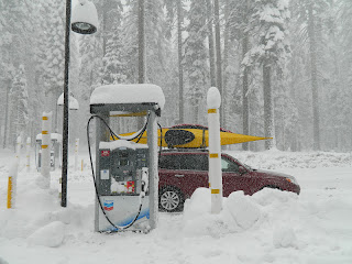
Unfortunately, we forgot to get gas in Mariposa, so our first need was to find a gas station asap. We were directed up Rt. 120 to Crane Flats to the only gas station, 18 miles from the gate, uphill all the way.


The snow started in earnest. Within minutes we were in a white out. Luckily we didn't blink and miss this tiny gas station just off the road in the trees.


Back down the hill and into the park for several hours of nonstop snow and three days of breathtaking beauty as the park revealed itself gradually.


At first all we saw was snow and trees.


Then the surrounding walls of the valley began to peek out. By the end of the day we caught a few glimpses of the rocky cliffs that Yosemite is known for, and actually saw a bit of blue sky.

Our last stop of our first day was Lower Yosemite Falls, where we also saw the only wildlife (other than birds) of the weekend.


Back the the motel we dried off and warmed up, and I had a long hot bath!!! for the first time in months. Read my yummy new book, The Laws Field Guide to the Sierra Nevada, as I soaked in the tub. Our efficiency motel room was bigger than our whole rig. Fun.

We woke the next morning to snow everywhere, and still more falling. Once in the park, we found a classic winter wonderland, and got more glimpses of the valley than the day before. These conditions led to some spectacular scenery though, of the kind photographers say they wait years for.  You can see how the photos begin to look like color instead of black and white.


Our first stop of the day was Bridalveil Falls.


After lunch at The Ahwahnee we headed out for more exploring and found one incredible scene after another.  I think we did enough of tromping around in the snow to satisfy Rick's winter fantasies.


A local photographer we met directed us to this gorgeous view of El Capitan along the Merced River at the Cathedral Beach picnic area.


Back to the motel for another hot bath and an OK dinner in their dining room. (I had been hoping for pizza in a big way.) On our last day we woke to even more snow on the ground, but a clear blue sky. There was easily over a foot in the valley. We had reserved a place on the 9:00 am Camera Walk led by a staff member from the Ansel Adams Gallery, and so hurried to get there in time.

Matt, our guide, was a professional photographer and gave us lots of advice about lighting and composition, and took us to a few incredible locations that we would not have found on our own.


Both these shots are of Half Dome from different locations.


He recommended we go to Tunnel View on Wawona Rd. so we did that and were rewarded by this amazing scene.


We hoped to visit the Tuolumne Meadows sequoia grove, back up Rt. 120, but when we got there found that it was a 2-3 hour hike in through deep snow and unfortunately we were not sufficiently prepared for that.  We did see a lot of big, gorgeous trees though, from a distance as well as up close and personal.


Coming back down the mountain we got this parting view, making the drive worthwhile.


Yosemite in the snow is clearly a once-in-a-lifetime experience, and I'm glad we tackled it. Never change your plans because of weather, but be prepared!