I've always wanted to go down into the Canyon on a mule, but never imagined it would really happen. I had heard that reservations were required 13 months ahead of time, and we're just never sure of where we're going to be that far ahead. But I had also heard that there was a day-before waiting list for cancellations, so I thought I'd give that a shot. When I called the reservation desk they said there were also some other openings! Four, in fact, for a few days away. So I snapped one up, complete with an overnight cabin at Phantom Ranch, and began my preparations. (Rick wasn't so interested so he volunteered for puppy duty. Thank you, thank you, thank you Rick.)
I found this map of the route we took, with the vertical profile in the upper lefthand corner. Many thanks to the
Chronic Climber Chick, who created the map and
hiked the whole thing. I knew I couldn't do that and I was so grateful there was another option. It is a very popular hiking route, but
only 1% of the almost five million people who visit the Canyon every year get down to the bottom by
any route or means.

Well, what does one bring on a mule ride into the Grand Canyon? All mule riders get about a two gallon sized plastic bag to carry anything you want to bring, so one must think very basic. Required is a wide brimmed hat with a chin strap, sunglasses, gloves, a bandana, long pants, long sleeved shirt and appropriate footwear. Obviously sun screen is a good idea, and dressing in layers. At the top it's a lot cooler than at the bottom. All food and water are provided, as well as bedding, towels and soap. Bathing suit and water shoes are also recommended for a cooling dip in Bright Angel Creek after a long ride down. I took all advice offered.
Two days before the ride Rick and I went to the park to scope out the check-in process and location. Check-in requires getting weighed, as there is a 200 lb. limit for all riders. They also want to give you all kinds of warnings and have you sign all kinds of informed consents and liability waivers. That done, all I had to do was stop at the Bright Angel Lodge registration desk to pick up my rain slicker before arriving at the Stone Corral at 7:50 AM, Monday morning.
The morning of I drove myself there and had a heck of a time finding parking. For anyone considering this trip, have someone drive you there, or stay at the lodge so parking is not an issue the morning of departure. I arrived late but it all worked out. It turned out there were only three of us on the ride that morning. A typical ride is 10-12. What a luxury!
(BTW there is no cell phone or internet coverage in the Canyon. Yeah!!! I brought my phone for its flashlight and alarm functions. Turns out an alarm was provided.)
My mule's name was Pauline. Here she is all loaded up with my stuff.
I learned a lot about mules on this ride. We spent about 12 hours with them over two days.
Mules are always the offspring of a donkey father and a horse mother. They are different from horses in many interesting ways. They have larger ears and smaller feet. They are strong, sure footed, calm, observant, smart, thoughtful and not easily spooked. All things you want in your mount under these extreme conditions. The guest and pack mule trains travel into the canyon 365 days a year, in snow, sleet, rain, hail, and sweltering heat. They are stopped only by rock slides that block the trail. Everything for Phantom Ranch that goes down or comes up does so on the back of a mule.
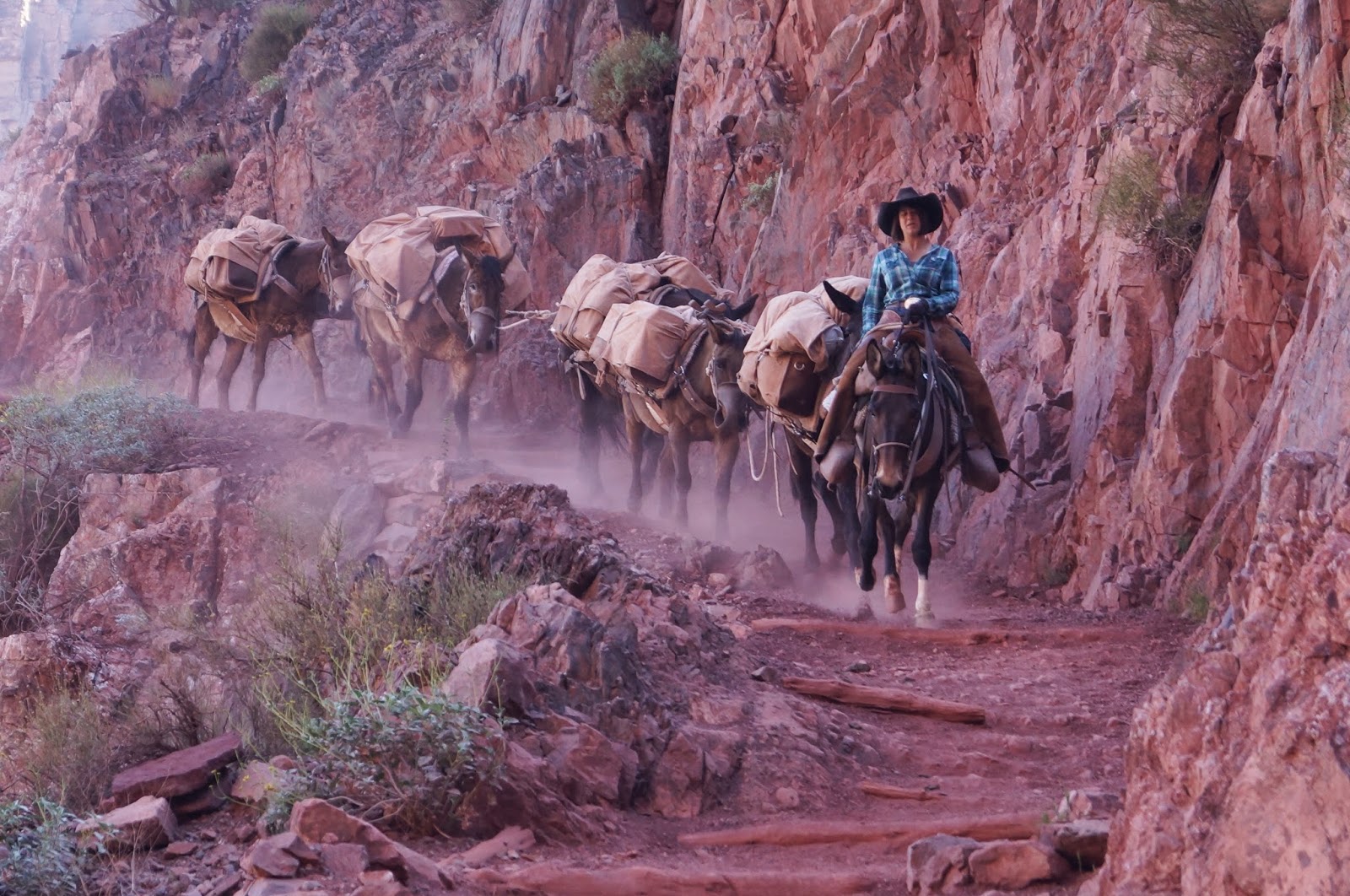 |
| A pack team going down |
These mules know every inch of the trail by heart and notice everything.
They follow one another and need almost no direction - just a little motivating now and then. Like everyone, they'd rather take it easy, take a drink, a nibble or a pee occasionally when the opportunity arises. But Pauline gave me absolutely no trouble at any time. I have to say I felt more confident on the back of a mule than I would have on my own feet when we were on very narrow and precipitous trails.

People always want to know if it's a scary experience. Being on top of a mule gives you a unique vantage point. When a mule makes a hairpin turn, his or her head sticks way out over the edge, giving you the feeling that you and the mule are just about to go head over heels down the canyon side. However, when their heads are sticking out over the edge, their feet (and the very substantial back 4/5th of their bodies, and yours) are still firmly on the trail. Once you understand and believe this, those hairpin turns are less frightening. But I'm not going to lie, those trails are narrow in some places, there is rarely anything resembling guard rails, and the mules sometimes like to walk very close to the edge. But as our most excellent guide Allison says, mules are seriously into self-preservation. They are not going to risk their lives.
 |
| Allison, our guide |
So, although the mules were the stars of the show, we were there to see the Canyon, and boy did we see the Canyon. I would have taken about 100 times more pictures, (and would probably still be down there if I did) but photography is hard on the back of a moving mule.
Most photos were taken during rest stops, either on or off a resting mule.

We took the
Bright Angel Trail down, a trail dating back to the ancient people who visited or lived in the Canyon. Our first real rest stop was Indian Garden, an oasis along the way with composting toilets and water to refill our bottles and to hose ourselves off from head to foot. Staying hydrated and cool is a big deal in the Canyon. Getting off the mules was a blessing for our legs as well. Going down is surprisingly hard work in the saddle.
 |
| Indian Garden |
With our first view of the Colorado we spotted a group of rafters. (They were much further away than this zoomed-in photo suggests.) This first raft was the scout, carrying much of the rafters' supplies. He's checking out this rock, as the water level around it helps him decide future routes through the upcoming rapids. We saw five other rafts follow him down the river, with more supplies and groups of 2-3 passengers each.
Once at the bottom, we rode the cliff edge above the Colorado on the narrow
River Trail for about a mile. There are only two bridges crossing the Canyon in this area: the Silver and the Black Bridges.(The Navajo Bridge crosses Marble Canyon at Lees Ferry.) The Silver Bridge is for hikers only. We went over the Black Bridge, passing through tunnels before and after.
 |
| The Silver and Black suspension bridges |
Once on the north shore of the river we entered the heavily vegetated Bright Angel Canyon and approached
Phantom Ranch, the only lodging in the Grand Canyon. It took us about six hours to travel the 9.3 miles from the South Rim.
 |
| The cabins |
Phantom Ranch has about 15 cabins of different sizes, a bath house and a canteen. All are very basic accommodations, but completely sufficient. Mule riders, hikers and rafters must make reservations months ahead of time, unless like me, they get lucky a few days ahead. There is no room for walk-ins. The Bright Angel Campground is also an option for hikers and rafters.
 |
| The bath house |
 |
| The Canteen |
 |
| Where our steaks were cooked |
 |
| Bright Angel Campground |
I was tired and very wobbly when I slipped off my mule and stumbled to my cabin. But after a short nap I was ready to explore. The North Kaibab Trail starts at Phantom Ranch and follows the Bright Angel Creek all the way to the North Rim. I followed it far enough to find a nice place to walk into the creek and soak off the dust and the heat. It was in the 90s down there and dry as could be. The water was just what I needed.
 |
| Bright Angel Creek, looking back at the South Rim |
A very pleasant family style steak dinner was served at 5:30 and 7:00. After my 5:30 seating I had enough time to explore a little further up the N. Kaibab Trail as the sun set.
 |
| Snapdragon vine in Bright Angel Canyon |
 |
| Veins of granite and schist in Bright Angel Canyon |
 |
| View from Phantom Ranch to South Rim at sunset |
Next morning, after a bright and early 7:00 hearty breakfast we saddled up and headed out on the 14 mile
South Kaibab Trail back to the South Rim. I had a very important role to play today. Pauline and I carried the US Mail out of the Canyon! Just like the pony express!
 |
| Two saddle bags with the US Mail, plus my souvenir water bottle |
The ride up is very different from the ride down. First of all, the mules have to work a lot harder, so we stop and rest more often. Sitting in the saddle is very different too. Going down, you have to lean back. Going up, you have to lean forward. Mules, or at least my mule, was not a smooth walker. That meant a lot of active adjusting with my back and core muscles to stay in the saddle, but it felt easier on my legs.
The S. Kaibab Trail is a newer trail than the Bright Angel, being built to bring materials down into the Canyon for the bridges and the water pipe. Oh, here's an
interesting fact.
All the water for Phantom Ranch and for all the development on the South Rim, comes from Roaring Spring on the
North Rim! Yes. That means it flows all the way down the north side and is
pumped up the south side. Seems impossible, but its true.
I'll try to give you a sense of the trail in relation to the surrounding canyon in the next few photos. In most of them you can see the distinction between the upper Canyon, which is all sedimentary layers, and the lower Canyon, which is metamorphic, very irregular and much harder. The dividing line is the pale green gently sloping area called the Tonto Plateau. Although in these pictures we're looking back at the North Rim, the same geological structure is present on the South Rim.
 |
| See the little ribbon along the bottom of the photo? That's the flattest section of the S. Kaibab Trail |
 |
| These switchbacks are called the Red and Whites I think |
When we reached the end, we each received one of these funny certificates to commemorate our accomplishment. I am now a Master Mule Skinner Cowgirl!
This was kind of a long post, but it was kind of a long ride. Thanks for riding along. Talk about adventure. This was the best so far. Now I want to do more. Rocky Mountains here we come!
Happy Trails Everybody!