"Could I have this dance for the rest of my life?" - Anne Murray

Thursday, May 15, 2014

Soap Box Derby: Cedar City, Utah

Ready for a flashback to a simpler time? This is not an app, computer game or any kind of a virtual experience. This is an authentic, nuts and bolts, homemade, main street, family and full-out community, hands-on event.


Have you ever seen a real life soap box derby? I don't think I have. I do recall the episode of the original Little Rascals in which some soap box cars played prominently.  Well, I jumped at the chance to witness the real thing in Cedar City. Here's how it went...


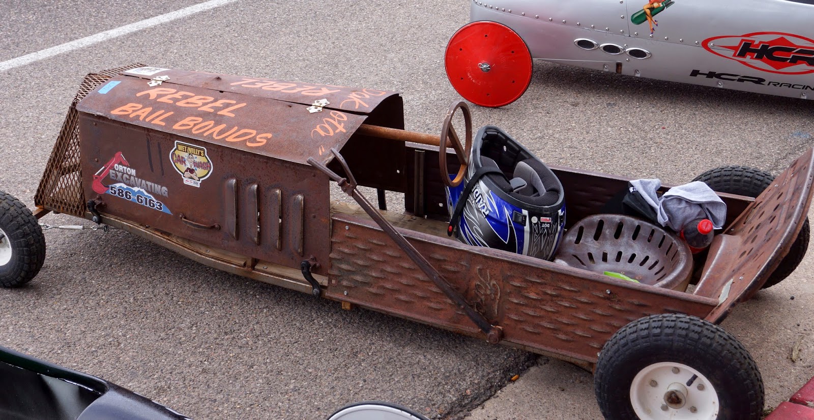
The cars line up at the top of the street. As you can see, soap box cars have come along way since the Little Rascals. Many are sponsored by local businesses, which I assume allows them to get pretty fancy. When their numbers are called, two at a time, the volunteer crew pushes the cars up the ramp into the starting gate.  


You'll recall,  I'm sure, that soap box racers have no engines…only steering wheels and brakes. 

On "GO" they roll down the ramp at not quite breakneck speeds...


..and on down Main Street, powered only by gravity and heart.


Some cars are "zoomier" than others (shades of Spanky and gang)...


...but all are cheered on equally until they cross the finish line.


 At the end of the race, the drivers steer their cars (or carts) into the pit.


The event was pretty much male dominated, but there were some girls and women drivers. 
(Yes, there was an adult division.)


In the pit necessary repairs are made... 


…and the winners go on to race again, and again, until the fastest car wins the whole shebang! 

I saw plenty of future racers in the crowd, waiting for their chance to roll.


I have to say, Cedar City, UT is doing something very right.

Wednesday, May 14, 2014

A Birthday Loop Around Cedar City, Utah

Our last stop in Utah was Cedar City, so we could try to see Cedar Breaks National Monument. The road into the park, Rt. 148, is usually closed until late May, but we thought we'd stop by the Visitor's Center in town to see if by some chance it was open. Success! The road had just opened.

For my birthday this year I planned a day that would make me happy - exploring the local area with Rick. I guess that's nothing too special - we do a lot of that. But I got to pick the whole day's itinerary.

Our first stop was for cinnamon rolls and a latte in town, then Cedar Breaks, then swing by Brian Head, through the little town of Parowan, on to Parowan Gap to see the petroglyphs and topped off with dinner at the Depot Grill in Cedar City. (We even had time for a little nap in the afternoon.) The loop started east on Rt. 14, cut north on 148, back west on 143 and then back roads out to the Gap and home.

Cedar Breaks was, as others have described it, a mini-Bryce. There was still some snow around, but it was verging on mud season. I'm glad the roads were all paved or it would have been a big mess. The few other people stopping at the observation areas with us seemed to be German tourists. I've got no explanation for that.

The view from Point Supreme. Brian Head in the distance.

Just north of Cedar Breaks is Brian Head, the southern most ski mountain in Utah. The whole place was closed up tight - no snow and no summer activities yet. Just mud season.

The back side of Brian Head

It looked like they were replacing one of the lifts, or putting in a new one. All the components of the lift were laid out in orderly lines in the parking lot.


After a quick necessary stop in the little town of Parowan we found our way to what was, for me, the high point of the day: Parowan Gap.  The gap itself is a natural geological formation that has been used as a roadway for hundreds, if not thousands of years. Although originally created by water running through a fissure in the Red Hills, the stream eventually dried up and now it is simply a "wind gap."


It is estimated that as long ago as 750 AD, Native Americans were using the gap as not only a passage, but a special place to record…uh...whatever it was they were recording there. No one knows for sure, but there are theories about the significance of the petroglyphs.  The prominent figure below is called "The Zipper" for obvious reasons, but the going hypothesis is that it is a recording of the location of the sun over time in relation to the sides of the gap.  Kind of like Stonehenge. If you're interested check out the link to Parawon Gap.


Even to a petroglyph amateur like me it's clear that these are atypical. The others I've seen are primarily pictures of animals and humanoids, with some wiggly lines and suns thrown in. The experts say these are all about counting, or keeping track with repetitive markings predominant throughout the site. 


On one side of the road the petroglyphs are protected by a fence, but on the other side visitors are free to scramble around and look for more. And there are plenty to find. This is by far the largest collection of petroglyphs I've ever seen. More even than Newspaper Rock near Canyonlands National Park. And they are really accessible. Just outside of Parowan, maybe 30 minutes from I-15. There's plenty of information on the internet to help you find and appreciate them.

Next a report on some more contemporary local color.

Thursday, May 8, 2014

A Final Hike on (probably not) Many Pools Trail in Zion National Park

Guided once again by Joe, our favorite Zion National Park expert, we headed through the amazing Carmel-Mt. Zion Highway tunnel to the east side of the park, a topsy-turvy world of swirling slick rock.  We selected a trail unofficially called Many Pools from Joe's website, and followed his excellent, detailed directions. After parking in a smallish roadside spot we found a sandstone culvert under the road that we thought must have been the trailhead. 


Above is a glimpse back at the culvert as we walked north, away from Rt. 9 along the wash. It was an easy walk through the wash until we came to some steep slick rock. But Joe had warned us about that and we had our nubby soled shoes on for climbing. 


We sure needed them as the trail progressed. "Slick rock" is the name for these eroded petrified sand dunes that make up much of the east side of Zion NP.  No, we didn't climb this one:


The wash continued north until we could see a white and red sandstone cliff that is so typical of Zion. We had a hunch that was probably the end of the trail.


Then we started seeing the many pools that this trail is named for.  This is my favorite picture of the pools and the cliff with the arch in it at the end of the wash. 


And this is the last of the pools, where we thought we would have to turn around and head back...


But, with a little exploratory poking around we found a "secret" passage hidden behind some rocks and brush...


…that led to a surprise slot canyon! Joe hadn't said anything about that!


We explored the canyon for about 200 yards until we came to a rock fall we didn't think we could get  safely over or around. We never did get to the foot of that beautiful cliff. The hike back to the road was even better than the walk in. It got a little bit cloudy so our pictures got a little bit better. This was our final look back over the slick rock toward our secret canyon.


When we got back home we looked up Many Pools Trail again on Joe's Guide to Zion National Park, and guess what? Nothing about our walk looked anything like his pictures of Many Pools Trail.  (Joe's pictures are fantastic - no big surprise that ours didn't look like his.) Yes, it had many pools, but there was no mention of any slot canyon. 

Where the heck were we, Joe?

An incredible place, that's where. This was our last hike in Zion, as we are heading north to Cedar City tomorrow.  We've spent a couple of days getting travel-ready again. We dismantled the folding kayaks because the roof rack is loose and we can't figure out how to fix it. So the kayaks are in the RV basement.  That took most of the day and reminded us again why we kept them assembled and on top of Ms. Subaru.  (Anyone want to buy a couple of great folding kayaks?)

Rick and I usually feel ready to roll after a month in one place, but both of us are feeling kind of sad about leaving Zion. It is truly one of the most remarkable places on Earth, and though we got into it more deeply this time than we did two years ago, there is still so much more to see. I think we'll be back.

Friday, May 2, 2014

Ice Cream Canyon (or Valley of Fire State Park, NV)

On our way to and from Las Vegas via I-15 we made the not-too-out-of-the-way detour to the Valley of Fire. So worth it. From the north you can get off at Exit 93 onto Rt. 169/Moapa Valley Rd. and drive south through the little towns of Moapa Valley and Overton. (There are no signs at Exit 93 for Valley of Fire.) There are some gas stations and a few small restaurants in those towns for replenishing.  From the south (Las Vegas) you can get off at Exit 75 at the Valley of Fire Hwy. It's not hard to find the park by either route.

Once in the park you begin to see the lumpy bumpy formations that are not untypical of southern Utah. 


These formations have many more holes in them than we've seen elsewhere, which is pretty unique. These holes are called tafoni and are thought to be caused by minerals coming to the surface of the rock through water seepage, and then breaking off or out, leaving behind holes. They come in all sizes, from caves to honeycombs.  The best picture I got of them is from the Atlatl rock. More about that shortly.


The Visitor's Center is at about the center of the park, and it would be easy to think you've gotten the idea of the park, and head out. Don't make that mistake! Turn north on Mouse's Tank Rd. and take the scenic drive to the end and back. You will not be disappointed, even if you don't have time to get out of the car at all. But if you do get out and hike you will be rewarded tenfold.


This is a very dry area, vegetated with only a few low bushes, yucca, cactus and wildflowers. 
It's really all about the rocks.


One stop along Mouse's Tank Rd is the Atlatl rock where you can view a nice collection of petroglyphs by climbing a long flight of stairs. (You may also get to see the tiniest desert rodents ever at the picnic area. The white-tailed antelope ground squirrel families are very friendly and fun to watch.) 


At Nina's (of Wheeling It) enthusiastic suggestion, we sought out the Fire Wave. (See their write up for easy to follow directions.) The hike is about 2 miles round trip at the most, and the trail is pretty easy to hike and follow. Watch for the cairns that mark the way over the slick rock. Even the cairns here are interesting to look at.


Aside: I got a new pair of hiking shoes that I am just crazy about. They're Chacos. You've probably seen Chaco sandals - they're all the rage, at least out West. But they also make these shoes. They're sturdy and fit like they were made for my feet. They've made hiking so much easier. Lucky me. 

OK. This photo gives you a sense of the dimensions of this place. That's Rick on the right, hiking the Fire Wave trail.


As you get closer to the wave, the rocks start to do their wavy melty thing 
and you may think you're there,


but keep going until you get to this...


...or this, if you approach it from a different direction. Here's where it all begins to look like an ice-cream sundae to me.  Maybe chocolate marshmallow here?


After climbing around and getting photos from every direction, we met a gentleman who told us to follow the wash down a bit further to get to the "pink canyon."


Well yes, it was indeed pretty pink, and gold...


...and orange raspberry sherbet swirlish. But this extension got us off the original trail and we ended up on the road for the hike back. I feel obliged to say that the park would like you not to do that as the road is very narrow and there is almost no shoulder.  Sorry! But the pink canyon was worth the detour and the risks of the road.


 A truly wondrous place. I hope you put it on your list and don't miss it if you must be in Vegas. 

We have only one more week here near Zion and I have so many more hikes to take! 


Thursday, May 1, 2014

Short View of a Long Hike

I didn't know the exact mileage, but I had a hunch it was going to be an all day hike. At 9 AM, I started at the Chinle Trailhead and at 6 PM, ended at Coalpits Wash Trailhead, crossing from one trail to the other on Old Scoggins Stock Trail.  Here's a map of the hike from one of my favorites sites, Joe's Guide to Zion National Park.

I brought about a half gallon of water, a lunch, my walking stick and camera, and took my time.  I think I probably stopped to look around about every 40 steps. That made it a longer walk that it might be for some folks. It was beautiful every step of the way, and so peaceful. I met only four people during the whole day.

Anyway, I took a lot of pictures of wild flowers and interesting rocks. I also took a lot of grand views, but I've shared so many of those I thought it was time to zoom in again to stay balanced.


It took me several hours today to identify all the flowers.  If you're interested, here they are, clockwise from the upper left corner: desert paintbrush, Shivwits milk-vetch, claret cup cactus, cliffrose, dwarf lupine, desert larkspur, sego lily, beavertail cactus, Mojave desert star, desert primrose, sneezeweed, bells of Ireland, skyrocket, yucca baccata, and purple sage (in the center).

If you read the list, you may have noticed one flower that is not a wild species at all, but a flower typically found in a florist shop. Can you guess which one? See the end of the blog for the name of this invasive non-native not-wildflower.

Here are the rocks. I can't begin to identify all of them, but most are probably forms of sandstone.  There's a plant with the sandstone in the upper right corner, maybe some gypsum layers on its left, and there are also some mysteries for you to ponder. Can you find the cryptobiotic soil? (Hint: it looks like a mini 3D map of Zion.) How about the petrified wood? (Answers at the end of the blog.)


The final question still lingering from this trip is, who made this track?


It's about 3" long and 2.5" wide. It was made in a damp sandy stream bed so it was depressed quite a bit. I don't see any claw marks. The bottom lobe has three bumps on the bottom and two on the top. I'd love to hear your expert opinions about it, 'cause I don't know. 


(Botanical and geological answers: Bells of Ireland, bottom row second from the left. Cryptobiotic soil, bottom row, far left. Petrified wood, bottom center.)