"Could I have this dance for the rest of my life?" - Anne Murray

Tuesday, September 25, 2012

Moab: The Needles of Canyonlands

The drive from Moab to the southernmost district of Canyonlands, called Needles, took about one and a half hours. I left Kona in daycare for the day so that I could take a few hikes and I was really looking forward to that.  My first stop along the way was Newspaper Rock Historic Monument, right on Rt. 211. It has one of the most dense collections of petroglyphs in one place anywhere.  


Here is a sample of some of the clearest of the many figures represented there.  Some are representational, while others look more abstractly symbolic. Really neat. I especially like the ones in the upper right that look like that big fuzzy character, Sully, from the animated film Monsters Inc.  Do you think they borrowed the image?


Once in Canyonlands, I stopped at the Visitor's Center to get an idea of what hikes to take and decided on Pothole Point and Cave Springs.  On the Pothole Point trail I saw my first really good example of cryptobiotic soil. All over the place in these parks there are signs saying "It's Alive!" referring to this kind of soil and asking visitors not to step on it.  Well I guess everywhere I've been it's already been stepped on to oblivion, because nowhere have I seen anything like this:


You can see on the left is regular sandy soil (with footprints), then rock, and then the cryptobiotic.  The soil thrives in potholes, and creates rich places for other plants to take root and grow too, like cactus and rubber rabbit bush are doing here.  I scrambled around on these huge flat rocks for awhile...


...and got some good pictures of the Needles in the distance.  There are not short hikes into the Needles unfortunately, so I had to be satisfied with the long view.


There had been no rain for awhile, so there was no water in the pot holes.  Looks pretty dry doesn't it?


But when it's wet, little creatures live in the potholes, like the tadpole shrimp that I saw in the Tanks at Capitol Reef.  

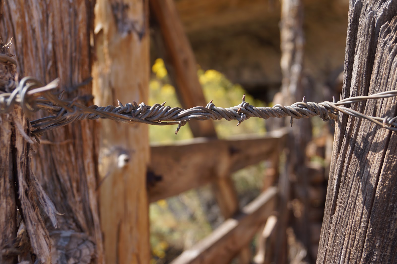
My next hike was at Cave Springs Trail, a green area fed by a spring emerging from under the eaves of more huge rounded rock mounds.  There is an old cowboy camp preserved there.  I was drawn to the construction of the old fences and the barbed wire bound around the joints, so I took this series of pictures.


The trail continues around, under the overhang of the rocks, in and out of caves they create.  In several places there are pictographs left by ancient native inhabitants of the area. Pictographs are different from petroglyphs in that they are made with pigments rather than carving or etching the stone. Sometimes they are combinations. These are all pictographs.  This one is a figure of some sort.


These are handprints, obviously.  It's pretty amazing how well the pigments are preserved. 


The trail then goes up two primitive ladders...


and across the tops of the rocks, revealing some big views.  The trail is not very evident up there, so you had to look carefully and follow the cairns.


The trail eventually scrambled back down the sides and under the ledges again, where I spotted this:


Until I came out west I had no idea what these were.  Now I'm pretty sure it's a pack rat nest, measuring almost a yard high and two yards wide.  If anyone has another idea of what kind of critter might have made this nest, let me know.

I finished my visit to Needles with a short drive down a dirt road to Elephant Hill, and then called it a day.  On the way home I stopped at the "world famous" Hole n" the Rock, on Rt. 191 just south of Moab.  I was dying for some ice cream, and strolled around the kitchy grounds while eating.  The actual hole in the rock is a home built in, yes, a hole in rock cliffs.  The home was inhabited during the mid-twentieth century by the Christiansen family. Now it is preserved and available for tours, and is surrounded by a general store, a gift shop, and a really mixed collection of sculptures and Americana kitsch.


This sculpture by Lyle Nichols, right out front, reminded me a lot of something I had seen earlier in the day, not far from this location:


Everything old is new again.

Monday, September 24, 2012

Moab: Arches and Windows

Here in Moab we are residing at Canyonlands Campground. It is not in the National Park, as the name might suggest, but right in the small city of Moab, within walking distance of almost everything the town has to offer. The park itself is fine, a little crowded, but folks are all nice and friendly. There are lots of international tourists and adventurous young people camping in tent villages. It's kind of a nice change. There is lots of shade - good for the heat and bad for the satellite, so we are without TV. They have a small pool, a laundry room and a fully stocked convenience store/Texaco gas station. Typical of the southwest, there's not a speck of grass anywhere, but Kona has adapted. 

One of the disadvantages of being right in town is the noise - often visitors to these urban parks are bothered by road noise or trains, or late night parties. But we had our first wake up call at 6:00 AM from the high school athletic field next door. Some enthusiastic athlete was running up and down the 15 tier aluminum bleachers making resounding thunder with every step. Then the marching band began to assemble and let loose in earnest at 7:00 AM.  Interesting. 


So, after exploring the two parks northwest of town in the morning, I left Kona at home in the RV with the air conditioner on and drove out to the Windows section of Arches NP at sunset. First I stopped at Double Arch and walked the short trail, passing this alcove. An alcove is an arch that hasn't eroded away from its supporting cliffside yet. I had been curious about what those are called. Most are much flatter than this cave.


The sun was not quite setting when I got to double arch. A busload of Korean photographers had just moved on so I got a nice shot without people. There are a lot of people in this park, especially compared to Capitol Reef. 


These arches are not easy to photograph. I got some of the warm direct sunlight on it, but even better was the bounce light from those direct patches that gave the whole inside of the arches a nice glow.


Very close to Double Arch is the Windows areas with three arches facing slightly different directions. There's a North Window, South Window and Turret Arch, and frankly I can't tell which is which now. 


There are several paths up and around the windows and one called the Primitive Loop that goes around the back side of them all. That was fun. This is one of the cairns that serve as trail markers all around here.  They make nice contrasting focal points to the huge rounded rock formations.


I think this formation is the Parade of Elephants. Looks like it, don't you think? I hope those who might know for sure will forgive me if I'm wrong. 


Tomorrow I'll drive south to the Needles district of Canyonlands, and Kona will go to doggie daycamp. 

Sunday, September 23, 2012

Moab: Dead Horse Point and Canyonlands


On day three in Moab, Kona and I got up before dawn again, packed lots of water, lunch, sunglasses, cowboy hat, hiking shoes and dog biscuits, and headed for Dead Horse Point State Park.  It's one of the places in the area that is recommended for sunrise viewing.


You can see why.


From the high mesa that is the park, you look out over the canyons created by the Colorado River.  Kona stayed in the car, for although there is a nice trail that dogs are allowed on, in places it travels very close to the edge and I didn't want to endanger either of us. 


It's been pretty hazy around here lately because of the fires in Utah and neighboring states. So unless I was focusing on areas in direct sunlight, or close by, I was getting lots of muted colors, as in the shot above.

The day and I were still somewhat young and cool...  : )  so I decided to go on to Canyonlands National Park, part of which is in the same basic vicinity.  Canyonlands is an immense park, divided into three major districts: Needles, the Maze, and Island in the Sky (where we went).  Like Dead Horse Point, Island in the Sky is up on a mesa, and the park has lots of opportunities to look down into canyons and over great vistas.  Because Kona was with me I didn't do any hiking, but just stopped at overlooks along the road and took some pictures.  (Dogs are not allowed on any of the trails in the NP.)

The first stop was the Grand View Point Overlook. 


There were quite a few overlooks. This one is called the Orange Cliffs Overlook. Really.


Further on we stopped at the Shafer Canyon Overlook, out on this peninsula into the canyon.


I thought the most interesting thing about this canyon was the Shafer Trail Road, a very long and narrow dirt road that starts in the nearby town of Potash and zig-zags up the canyon walls until it ends on top of the mesa.  It is not a road I'd want to drive in Ms. Subaru or any other vehicle. No sir-ee bob.


By then is was getting too hot for dogs and fancy ladies, and these days that start off before sunrise are lo-ong. (I've been listening to too much Blake Shelton. I'm developing a good ol' boy twang.) We got back to the RV and like yesterday, took a nap. But we were back up again for more fun at sunset! 

Saturday, September 22, 2012

Moab: Where to Start?

Wow! There is so much to see and do in Moab, Utah. In this town everyone seems to be hiking, biking, climbing, rafting, ATVing, jeeping, scenic driving, as well as eating and drinking, from dawn to dark and beyond.  Rick left for LA for a few days, so I'm on my own with all of these options. There are many I am not even considering, so the choices aren't really that hard. (I am not rock climbing, dirt biking, or ATVing. So there.)

Our first day here, before Rick left, we took a quick afternoon driving tour of Arches National Park, just to get the lay of the land.  Arches is high above the town of Moab, and has lots of huge rock walls, towers, needles, balancing rocks and arches that are kind of isolated from each other, a little bit like Monument Valley.  Many of them are named, like this one, The Three Gossips.


Below are some of the smaller formations. Ms. Subaru would be dwarfed compared to many of the others...


...like this one.


And this is the arch that is on much of the Moab literature. It's called Delicate Arch.  If you look really closely you can see some little white dots below it. Those are people.


The first day Rick was gone, Kona and I hiked Negro Bill Canyon at dawn. We were the first ones there, and we didn't see many other people until we were almost done.  It was the longest and hardest hike she's ever been on, bless her heart. It's about 5 miles round trip, but what made it so worthwhile for her was the clear cool stream that runs alongside the trail for most of the way. She was really motivated to find the next pool she could dive into.


The canyon is red and cream colored rock, and the trail sometimes climbs up onto the rock. At other times it runs right along the stream, crossing it about six times as I recall. There are stepping stones at all the crossings.


The hike ends at Morning Glory Bridge, where we rested awhile, listening to the little stream that gurgles out of a crack in the rock.


It's kind of hard to tell what you're looking at here, but that's the bridge going vertically up the middle of the picture. Imagine standing right below it at one end and looking up. It's a huge bridge and impossible to get in the picture.


Kona was just happy to find yet another place to get wet.


There were a few places that I had to bribe her to climb up or down pretty steep places with no good doggie footholds, but she did it!

This was one of our favorite shady spots.


It was a long, hot walk, and we were dragging by the end. It was all we could do afterwards just to go home and take a nap.


Over the next few days we visited Dead Horse Point, Canyonlands and Arches again.  I'll post about those tomorrow.

Sunday, September 16, 2012

Hike in Capitol Gorge and The Tanks

The Capitol Gorge trail is another one of the hikes identified as "easy" in Capitol Reef National Park.  At the end of the Scenic Drive, (the only part of Capitol Reef that "requires" a $5 vehicle fee) there is a dirt road off to the left, with a sign for Capitol Gorge. RV's are not allowed on the road, so there is a parking lot for vehicles over a certain length. The dirt road was easily passable for Ms. Subaru today.  The drive itself is pretty spectacular, passing through the beginning of the gorge.  At the end of the road is another busy parking lot, and I expected that I'd be hiking with a crowd, but that didn't turn out to be the case.  The Golden Throne Trail, a "strenuous" hike, also leaves from that lot, so some folks might have been there.


The hike travels through the Gorge, following the old road that has been used for thousands of years, first by the Fremont people, then by Mormon pioneers. About 1/2 mile in there are some petroglyphs that aren't in great shape, and then further on is the Pioneer Register.  A lot of people just take the hike that far.


The Register is a place in the Gorge where early settlers left their names or initials and the date. There has been some copycat and destructive graffiti unfortunately, so sometimes it's hard to tell what you're looking at.  Most are from the late 1800's but one of the clearest, on the right side and quite high up is from 1911. 


Further down the trail, the walls of the gorge recede and other formations come into view. 


I don't know where this trail ends, because after a little less than a mile, I had a choice to make.  I've been doing some exercises to strengthen my knees and core muscles, and I am almost feeling ready to take a "moderate" hike.  This explains my spontaneous decision to extend this hike to see The Tanks.  It required some scrambling over rocks and some pretty steep step-ups, but I was fine. The trail is sometimes hard to follow, even for one so frequently used, but there are plenty of markers in most places.  You just have to pay attention.


The Tanks are a series of pools that are remnants of a seasonal stream that must have been very strong at one point in geological history.  I hiked as far as I could up the gorge that contains the Tanks.  I suppose if folks are prepared to hike in the water they could go further.  I walked around the edges of the water, which wasn't all that appealing, as at this time in the season it's stagnant, fed only by the monsoon rains. 


Some of the Tanks are deeper than others, and I only saw two odd little creatures in them, that might have been tadpoles or some kind of freshwater shrimp.  Great reflections of the surrounding rocks though.


After climbing to the last Tank, I walked back to one that looked inviting, took off my shoes and socks, soaked my feet and cooled off. 


The whole time I was the only person at the Tanks. 


It was completely silent, and it gave me some time to notice the details.


Once cooled off and rested, I started back down toward the main trail. The Tanks descend like a staircase down to the wash/trail, but that route is not navigable without climbing apparatus. 


I scrambled down that way far enough to see the natural arch formed by the rushing water and sand. 


Once back on the main trail, it was hot, and I was glad to at times walk in the shade of the high canyon walls. In places there was still some damp mud, looking a lot like melted chocolate. I was getting hungry too.  Found these little lizard tracks in the chocolate - I mean mud. 


The hike was about 3 miles round trip I think.  I felt hot and sweaty but great.  I'm definitely ready for a "moderate" hike.


Back on the road a sign pointed out the Golden Throne, which I'd missed on the way in. 
As I've noted before,  the reverse direction often reveals something new. 


Well, this is probably the final view of Capitol Gorge. It's been a great visit. Tomorrow, on to Moab for more adventures.  Come along...