"Could I have this dance for the rest of my life?" - Anne Murray

Thursday, August 30, 2012

McCall and Mountain Home, ID

While in McCall we stayed at the McCall RV Resort, one of the G7 RV Resorts.  It's a somewhat large, multi-tiered park, in a nice location just outside of town and along the Payette River. It has a great indoor/outdoor pool and an indoor hot tub, with 6 private spa quality bathrooms/showers. The sites a large and nicely landscaped, with some shaded. We stayed in one of their "quads" which I'd never seen before, where four pull throughs are arranged as the sides of a square, with a green space in the middle. It makes it easy to meet your neighbors, and easy to party together if you are camping with a group. There was a little partying going on in one of the quads near us, complete with ukulele playing and singing! That's a first for us too.

The view from the lower tier of the resort, of the river and the adjacent public park is great.


There is a large wooded and wetland area next to the RV park, perfect for taking walks down to the river. Kona got to swim a couple of times.  I got up early on our last morning there and got these misty pictures of the river.


There's lots of wildlife in the area as well. Twice on the morning that I took these photos, I saw ospreys diving into the water to catch fish. The sound was surprising - like someone throwing a ten pound rock in the water. We saw deer and three resident foxes (often), who the resident people feed (unfortunately).


The Payette River also seems to have a northern branch the feeds into Payette Lake, though I'm not sure that is the correct name for it.  We went kayaking on that river, and in my opinion it is the most perfect kayaking location (for us) that we've been on so far. It has a gentle current, no white water, and meanders through forest, rocky cliffs and wetlands, providing interesting and varied scenery.


 There are several easy places to put in your non-motorized water craft, like this one where we launched our kayaks easily.


The river meanders all the way to the lake, in case you want to paddle there as well. There are several sandy beaches on the river and the lake, so swimming is definitely an option. The water is crystal clear so the bottom is also interesting to see. Supposedly there are salmon, beaver and otters living in the river. 


After we left McCall, we headed south along Rt. 95 to Mountain Home.  The scenery changed dramatically from wooded mountains, to farms, and finally to desert. We are now at the Mountain Home RV Park.  It has the longest sites we've ever seen, and if they just had a pool, we'd give it a perfect 10.  Although it's not the the most scenic area, the park is run so efficiently, and so well taken care of, that it's a pleasure to be here. It's still a work in progress with lots of space to expand. So this is great place to do all of life's normal things that go between adventures: cleaning, reading, planning the itinerary, cooking, laundry, shopping, repairs, watching the US Open and the GOP Primary, and resting, because there isn't a whole lot nearby to visit.  

There is the Bruneau Dunes State Park, about 40 miles south, and we went there this morning for the sunrise. 


It's a relatively small dunes area compared to some in the US, but it does claim to have the tallest single dune in the country. It basically has two - a big one and a little one. Here they are:


The dunes are next to a shallow lake, where I saw this heron.


Route 51 crosses the Snake River south of Mountain Home and we saw several flocks of white pelicans in this location that were too far away to photograph well. The Snake River sure does get around. 


Somewhere near here is the Snake River Birds of Prey Conservation Area that we may get to before we leave.  Other than that, we're just chillin'.  This is our last stop in Idaho; we'll be heading to Utah on Sunday.

P.S. No fires near here, though there are several huge ones in Idaho right now.  Sometimes we get the smoke in a hazy, dissipated way. I guess they're having a really hard time containing them. We saw the smoke jumper center, and the planes and helicopters that work out of McCall. Thank goodness we happen to be skirting around the fires.

Wednesday, August 29, 2012

Why?


Self portrait


Sometimes I wonder why Rick and I are doing this. Of course I can only know that for myself; Rick would have his own answers. So for myself, I wonder what is my purpose now? Yes, I have this opportunity for adventure, to explore new possibilities, to create my life everyday, but what is the greater meaning of it all? How do these experiences feed my soul, renew my spirit, support my relationship to God, or help me find my way to heaven?

My answer comes in part by paying attention to what parts of my life give me feelings of wholeness, of joy, of love.  Without getting too personal about this, let me just say that living in a 400 square foot box with another person 24/7 is a labor of love. Everyday is another opportunity to learn how to love better.

As an individual though, there are two circumstances when I feel like I am growing into my understanding of spirit and a meaningful life. The first is when I encounter difference, which happens a lot when traveling in this country of ours. (It happens in our own RV!).  I used to feel so strongly about some things: my values, my ideals, my beliefs, my work, and I hung out mostly with those people whose values, beliefs and life styles were like mine. Now, in these encounters with people who do not seem to be like me in the ways I am familiar with, I find myself holding my values and beliefs more and more lightly, and simply listening to those of others without a strong response.  I just am not that important.

The times I feel most connected to my spiritual sense are when I am in the natural world, paying attention, listening, watching, becoming invisible. This moving around and witnessing others both human and nonhuman has reinforced my growing sense of invisibility. It's kind of hard to explain, but I found this song by Walt Wilkins that helps me say it and helps me understand the meaning of being invisible. (The italics are mine)


Up and On My Way
by Walt Wilkins

I am sky.
I am stone.
I am dreams
and I am bone.
I am never alone,
and I'm up and on my way.

I am sand,
the whole shore.
I'm the shining sea
and what's more,
I'm every wave that's come before
and I'm up and on my way.

     Tonight gives way
     to another brand new day.
     Come what may,
     I'm up and on my way.

I am green.
I am blue.
I've been broken
and patched up too.
And it might take an ocean of blue,
and I'm up and on my way.

I'm as tall as a tree,
but there's something going on here
bigger than me.
Something I can't wait to see,
so I'm up and on my way.

I'm a child
full grown.
I'm always half way home
so I'd better be moving on.
I'm up and on my way.

     Tonight gives way
     to another brand new day.
     Come what may,
     I'm up and on my way.

Sunday, August 26, 2012

Hell's Canyon - Lewiston, ID

As I said in my last post, I chose Hell's Gate State Park for its access to Hell's Canyon, the deepest canyon in the US. (Bet you thought the Grand Canyon was. Me too!) There are several companies that offer raft and jet boat tours in or near Lewiston and they all like to say that they're "not all the same." Among the jet boat tours, they all use similar boats, which are aluminum boats that hold as many as 50 people (our trip had about 25), and are powered like jet skis, needing only a 9" draft underneath, to prevent mishaps with the rocks in the Snake River. They differ by how far they go into the canyon, but all are approximately the same length, with full and half-day options. They differ by where they stop for lunch, each contracting with different lodges or restaurants along the river.

We chose Riverquest Excursions and were very happy with them. We chose a half-day trip, which was really a pretty full day. We left at 10:00 am and returned at about 5:00.


We left from the marina right at the state park.


Captain Butch is Coast Guard Licensed and is the owner/operator of the company. He also leases and manages the ranch where we stopped for lunch. More about that soon.


Shortly after we embarked we passed cliffs of what are called basalt columns. Some of them are vertical, like columns, but others are in fan formations, or horizontal. The whole area was volcanic, with evidence of other geological forces, such as water erosion and massive flooding.


After jetting up the river (going south) for awhile we pulled over at the site of these ancient native American petroglyphs and pictographs. (Pictographs have color or paint in them as well as carving.) You can see how some near the top are colored red. The bright spot is a lazer flash light used to help point out figures on the rock. Some are unfortunately obscured by a small bush now.  


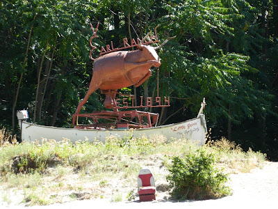
A little further on we passed the Earl Ranch (est. 1894), one the of the few working ranches on the river. Many have been started, but few last. This rancher has bought out many neighboring ranches, which seems to be common among those that succeed. This sculpture of a steer was created by the owner. To give you a sense of scale, see the old boat seat down in front of it? 


The water alternates between flat and class I and II rapids in this part of the river. The jet boat, ably navigated by Capt. Butch zipped right over the water.


The banks of the Snake River are typically either white and black rock, or sand. There are lots of really beautiful little sandy beaches along the way, often with kayakers, rafters or jet boater stopped to swim or picnic on them.

We stopped for lunch at Garden Creek, an old farm leased by Captain Butch and Riverquest Excursions from the Nature Conservancy. It is a cool and lush oasis surrounded by desert. We sat in the orchard and ate our provided box lunches. 


After lunch I strolled around the farm and visited with the resident wild turkeys


and deer who were enjoying the grass and the dropped apples.


Right outside of the orchard, you step into the desert.


The walkway to the farmhouse had an arched gate with this typical Western decor.


After lunch we took a quick dip in the very cold and fast moving river. It sure felt good to cool off. It was probably about 100 degrees in the sun.  We continued south, up the river, passing more scenery along the same themes of dry, striated rocky canyon walls, 


and this rough rock along the water. The white rock marks the typical high water mark, and the shiny black rock above it has been scoured by sand and debris from fast moving high water. 


We made one more stop before we reached the end of our journey up the river.  Unfortunately I can't recall the name of it, but it was part of the national forest system, an old farm, with an orchard and turkeys. This one also had a small historical and natural museum of the area.  Next to the house was this old root cellar/cool storage area, shown here inside and out. 


It's no longer in use. In fact the couple that was volunteering there for the month as caretakers were really struggling with the heat and with not having fresh water. Our captain dropped off several large jugs of drinking water for them. They are really isolated except for the tour boats that come by.


The view from the picnic area shows again the contrast between the oases that have some water source and dryness of the surrounding area. 


Back in the boat and on to our final destination, a place called Dug Bar.  All along the way our captain told us stories about the history of the river and the canyon, complete with gold miners, steam paddle boats wrecks, Native Americans pre and post encounters with white folks, and more. 

Once we started back down the river, or north, the going got a little rougher and the boat had to go faster to avoid getting caught up in the current in a dangerous way. We really whipped around some of the bends in the river and to avoid large rocks. 


Whoa!!!


This view is looking through one of the narrowest places in the river. 

About half way back, we were all pretty hot, so our captain was kind enough to stop at this waterfall and let us stand underneath it if we wanted to cool off.  


Of course we couldn't pass up an opportunity like that, and it was COLD!


Almost home, and we spotted our second group of longhorned sheep.  Both times they were right on the banks of the river, heading down to get a drink. This group were all ewes and kids of various ages who had to cross a large split in the rock to get to the water.  

This one had just successfully jumped across and was looking back at another, saying 
"Mind the gap!"


The next one was hesitant and decided to find another way down.


And this little guy jumped right across, following his mom.


This kid took his time down by the water. It was a thirsty day for all of us.


We were sure ready to be home by 5:00. I can't imagine what a "full" day would have been like. 


Thanks Captain Butch!

Alive and Well in Idaho

Apologies for the long delay. We spent some time in areas where we weren't getting cell or internet service. Combine that with Rick working on a project for a friend and getting into his own photography, both of which require use of the computer, and I just got out of the routine of writing the blog and working on my own photos.  We may have to consider getting another computer, which we never imagined we'd need.  Maybe Santa will bring us one this year.  : )

We've been in Idaho for about three weeks now, starting in Post Falls, then Lewiston, and now McCall.

Post Falls,  ID

Post Falls in just west of Coeur d'Alene, Idaho, a much raved about resort town on the much raved about Lake Coeur d'Alene. Although it is nice, it didn't knock us out, and as far as we're concerned doesn't hold a candle to Flathead Lake, Montana (our favorite).

My big accomplishment for this stage of our trip was learning how to spell and pronounce Coeur d'Alene (say coor-de-lane).

We stayed at Coeur d'Alene RV Park, which was also very nice but didn't knock us out. A warning to those who may want to stay there: It has a heck of a challenging entrance - very narrow, with stone walls on each side, and no signage until you're right on top of it. What were they thinking?

We explored around a bit, visiting the falls after which Post Falls is named.  The town has several very nice parks on either side of the river.


Kona and I took a little rocky hike in Q'emlin Park across the river from the town of Post Falls.


Interesting signage here for the local clothing optional beach, which you can just barely see in the upper left corner of the above picture. Don't strain your eyes, there were no people at the beach, even though it was a very hot day.


While in Post Falls we drove up to Lake Pend Oreille (say pon-de-ray) to the town of Sandpoint, where they also have a really lovely town park with a large beach and even larger grassy picnic area, but dogs are not allowed. : (

We also drove around Lake Coeur d'Alene and discovered a very long bike path and some cool places to kayak, both of which we took advantage of on different days.


We found (thank you Google) a really yummy pizza place in Post Falls, Nate's New York Pizza. Being a New Yorker, I am particular about my pizza, and traveling across the country has been a challenge to my pizza loving tastebuds. But we take the risk about twice a month and have actually had a lot of good pizza. My New York pizza snobbishness is in remission. 

Lewiston, ID

While in Lewiston we stayed at Hell's Gate State Park.  I loved it, but Rick was not so thrilled because we couldn't get internet, TV or cell phone service. Can you imagine? It's a wooded campground, thank goodness, because it was HOT while we were there, but those trees got in the way of our satellite reception.  


 The park has hiking and biking trails that pass right through the campground, and a large sandy beach on the Snake River, all of which we took great advantage.  I splurged (the heat made me do it) and bought two floats for us to play with. I don't think I have ever had a float and just getting into it and splashing around made me laugh so hard. I don't know how I've lived without them so long.


I scheduled a stop at this State Park so that we could take a boat trip on the Snake River through Hell's Canyon. (More about that in my next post.)  The park is actually in the upper (or is that lower - the river flows north here) Hell's Canyon, and aside from the very green (irrigated with river water) park itself, is surround by desert with some interesting volcanic rock formations. 


Our first morning there I got up at sunrise and headed out of town, out of the canyon in which Lewiston sits, and up onto the surrounding plateaus to take some pictures of the wheat farms. The light was great and the smell of the freshly harvested land was heavenly. Here are a few of my favorite shots.


 It was harvest time, so there were all these great contoured patterns created by harvesting around the rolling hills.


I believe most of the fields were wheat, but there may have been barley and different varieties of wheat as well. Some fields, like this one, looked like they weren't ready yet, and were drying or ripening at different rates depending on where the soil was moist.


Going back down into Lewiston I took the old road that winds down the canyon side.


Next post I'll finish up Lewiston with our trip through Hell's Canyon, and move us on to McCall.