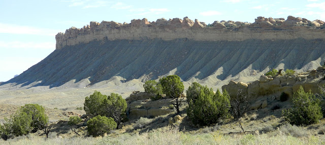
The day started overcast and hazy as we headed through the parts of Capitol Reef we'd visited before, so we didn't take any pictures there. Once we turned south on Notom Rd. the vista opens up to reveal several mesas to the east and the Henry Mountains in the distance.
It was still kind of cloudy when we got a good look at some of the most interesting rock formations we've seen. As we watched, the clouds started to break up a bit, so we got some interesting light on them. The locals call them the cinnamon rolls and I think that's an apt name. They are part of the Waterpocket Fold (more about that later) and are huge. Not sure you can get a sense of scale here, but they are quite far away in this picture, and each "roll" is mountain sized.
A little further on we passed this isolated formation on the left, and thought "Oh Boy, we're getting into some interesting stuff now!" But this was just a tiny preview.
Notom Rd. turns into dirt after awhile, and does go through a few washes, which were dry fortunately. After rains this road would be impassable without high clearance and four wheel drive.

About half way to the Burr Trail turn off, the road passes through Sandy Ranch and a green valley fed by Sandy Creek and Oak Creek.
Irrigation from these two creeks allows for grasses and grains for cattle and horses in this area. In the distance is more of the Waterpocket Fold.
The terrain in this area is not just a lot of red rocks; it is tremendously varied. In this view alone you can see high mesas with forests, red cliffs, cream colored Navajo sandstone, multicolored badlands, sand dunes, and piñon-juniper shrub.
Now, about the Waterpocket Fold, which is the 100 mile long defining geological feature of Capitol Reef Park. It is a place where the earth's crust has basically wrinkled, uplifting and exposing ancient layers of sedimentary rock, and then eroding to create a basin that gathers water. The link I've inserted here will tell you in more scientifically accurate language what the Fold actually is.
The Fold is so huge, you can usually only see small parts of it from any location. There are exceptions from a few overlooks that we hope to get to before we leave. There are places where we were able to look down along one of the ridges to see the different layers of rock and get some sense of the whole.
The stop we made that resulted in the above and following pictures was on the Notom Rd. north of where it meets Burr Trail Rd. We got out and climbed among the rocks, up over a ridge, and the view above opened up for us. The day had cleared up completely by this time.
Here we are basically looking down into the Waterpocket Fold. Based on the descriptions we had read we kind of expected to see water, but obviously that's not the case.
The white colored rocks are part of what's called the Oyster Shell Reef.
The layers of rock and the different ways they respond to erosion are evident in places like this.
The Burr Trail Scenic Backway is named after the trail established by John Atlantic Burr in the late 19th century to drive his cattle from winter to summer ranges through almost impassable territory. You can see the ribbon of dirt road in the next picture, taken from a viewpoint looking east and down at the Burr Trail switchbacks.
After ascending the heights of the Waterpocket Fold there is a hike to the Strike Valley Overlook that we chose not to take, but it supposedly provides a "striking" perspective of the Fold.
Shortly after that, Peek-a-Boo Rock comes into view, which we had just barely seen from below. This view is from its west side.
The Burr Trail takes you into the Grand Staircase-Escalante National Monument, the northern border of which is the marked by the Circle Cliffs, visible in the distance from the road, but not in any of my photos. About halfway to Boulder we came to the Long Canyon Overlook, which I assumed meant we were looking over Long Canyon, right? Well no, it's at the end of the canyon, but for us it was the beginning. We were looking back at piñon-juniper scrub land and eroded multicolored sands. The Long Canyon was next.
The Long Canyon is something like that in Zion National Park, except you can drive through this one and its much longer. The cliffs are immense and beautifully shaped by the splitting and shearing of the rock.
In many places there are arched caves being created.
We stopped for a look back at Long Canyon.
Burr Trail ends in Boulder, UT, a very small town with a gas station, and a couple of restaurants and lodges. We stopped for some gas and headed north on Rt. 12. Boulder is surrounded by large outcroppings of slick rock.
Slick rock is basically exposed petrified sand dunes, and the cross cut ridges are evidence of wind action on the sand. Heading north took us up into the high chaparral and cotttonwood groves of the Dixie National Forest. Our last stop was an overlook back at where we had been, and the Lower Bowns Reservoir.
Route 12 took us to back to our home in Torrey for the next 10 days. We each took a long nap. We'll be exploring more of the Capitol Reef area and should have some nice pictures. Thanks for reading!


No comments:
Post a Comment
Want to leave a comment?